Destination

icons
Duration
15 Days 14 Nights
icons
Tour Type
Expedition
icons
Group Size
16
icons
Tour Guide
6
Uttrakhand

Auden’s Col Expedition

Trek Name: Auden’s Col Expedition

Days: 15

Adventure Type: Trekking

Base Camp: Gangotri

Season:Summer | Autumn |

Month:June |

Country: India

Altitude: 18000 Ft.

Grade: Challenging

Rail Head: Dehradun

Stay: Guest House & Camping

Food: Meals while on trek & at Guest house (Veg & Eggs)

Location: Uttarakhand

Distance: 95 Km.

Trail Type: Cross over trail | Start in one valley, traverse the pass, and ends in another valley.

AirPort: Jolly Grant Airport, which is 28 km away from Dehradun

Details

Why Auden's Col Expedition Is A Must-Do Trek?

1. Historical Significance:
  • Auden's Col holds a significant place in Indian literature and mountaineering.
  • Named after John Bicknell Auden, a pioneering geologist and explorer who first crossed the pass in 1939.
2. Unique Geographical Features:
  • Connects Rudragaira and Bhilangna Valley, offering a diverse and captivating landscape.
  • Positioned between the imposing Khatling and Jogin I glaciers, providing a stunning backdrop for the entire trek.
3. Spiritual Journey:
  • Beyond being a challenging trek, Auden's Col holds spiritual significance as it connects the Char Dham of Gangotri to Kedarnath.
  • Culminates at Kedarnath, one of the Char Dhams and a revered Jyotirlinga, making the trek a spiritual journey.
4. Enchanting Lakes and Meadows:
  • Presents an array of crystal-clear lakes like Sukhatal, Masar Tal, and Vasuki Tal along the route.

  • Altitude: 3,100 m / 10,200 ft (Gangotri).
  • Pick up time 06:00 am from Prince Chowk, Dehradun.
  • Drive 240 km, 8-9 hours from Dehradun.
  • Breakfast and lunch on the way (not included in the cost).
  • After Uttarkashi keep a warm jacket handy.
  • Local Market and network is available.
  • Full functioning AMT at Uttarkashi.
  • Gangotri is one of Char Dhams of Uttarakhand.
  • Dinner at guest house (included in the cost).
  • Stay in Guest House (double or triple sharing).

Once you arrive at Dehradun, get all ready to start your long drive to Gangotri. As you know it is one of the most religious places in India. You will cross Uttarkashi, the place having the NIM mountaineering institute. Uttarkashi is a town located on the banks of river Bhagirathi. The drive goes through temples and dense forests until you reach in the evening.

  • After breakfast visit Pandav gufa, Gauri and Surya kund.
  • Post lunch can visit Gangotri temple or go for shopping.
  • Lunch at guest house.
  • Stay in Guest House.
Wake up in the religious land. Today try to utilize the day to know about Gangotri. You can visit temples, caves, walk in the woods, meet Sadhus, etc. Together with the group, you can visit Surya Kund, Pandav Gufa and GauriKund also. Try not to miss the Aarti. Today is acclimatization day so stay outdoors and get used to the height.
  • Altitude: 3,750 m / 12,300 ft (Nala Camp).
  • Altitude gain: 650 m / 2,100 ft.
  • Trek: 8 km | 6-7 hours.
  • Moderate walk with steep ascent.
  • Walk along with the river.
  • Initial trail is with Bhagirathi River and with Rudugaira River.
  • After 2 hours of trek cross the river over a log bridge.
  • Walk in the forest of Pine, Cedar, Rhododendrons, and Birch trees.
  • Can see Gangotri III and Jogin II just before the campsite.
  • Packed lunch on the way.
  • Stay in a tent (Twin sharing).

After good acclimatization stay in Gangotri, and get walk towards Nala Camp. The trek will of 6-7 hours through the moderate and steep trail. You begin by going down the main valley. You will be walking along the Bhagirathi River. After 2 km cross the log bridge on the river then take a right to enter Rudragaira valley. You will be walking through dense Pine, Cedar, Rhododendrons, and Birch trees.

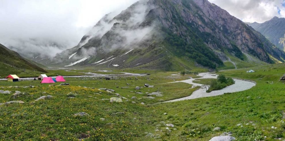
The trail then suddenly climbs up. You may also have to pass through the rockfall zone, so be careful. As you gain height you can see the forests becoming less visible. Later you can find grasslands bloomed with flowers then come into eyesight. You can also see a glimpse of Gangotri III and Jogin II. The campsite is on the wonderful meadows beside Rudragairariver. So, enjoy it while your night stays in tents.

  • Altitude: 4,350 m/14,300 ft (Rudugaira Camp).
  • Altitude gain: 600 m/ 2,000ft.
  • Trek: 7km, 7-8 hours.
  • Steep and strenuous climb all the way.
  • Views of Rudragaira peak, Jogin peak, and Auden Col pass.
  • Cross a stream and landslide area.
  • Less water sources on the way.
  • Packed lunch for the day.
  • Stay in a tent.

Today will be a short yet difficult day. The entire trail is a steep and strainful climb. There will be no water sources on the way. Make sure you carry enough water. Moving through Nala the trail will go up towards high meadows.

  • An acclimatization day at this height is mandatory.
  • Explore and enjoy campsite surrounded by peaks.
  • Can climbed a ridge towards Rudragaira peak.
  • Hot lunch at campsite.
  • Stay in tent.

Since you are at 14300 feet it is necessary to give your body the time for acclimatization. Explore the campsite. Make the most of this stunning campsite that is between huge peaks on meadows beside a gushing river. If you wish to you can go for a small hike on a ridge near the campsite. Try to stay out of the tents to boost the process of acclimatization.

  • Altitude: 4,750 m / 15,600 ft (Auden’s Col BC.).
  • Altitude gain: 400 m / 1,300 ft.
  • Trek: 8 km | 6-7 hours.
  • Gradual and tricky ascent on moraine.
  • Carry enough water from the campsite.
  • Beautiful views of Gangotri peaks.
  • Pass Sukha Tal on the way.
  • Can see the gully leading to Audens Col.
  • Packed lunch on the way.
  • Stay in a tent.

Today will be an exciting day with a lot of surprises. First, start by walking on moraines. Once you cross a landslide area you will reach the top of the ridge. Keep walking on the ridge and climb down till Bakriwala camp. After crossing a stream another ridge will come ahead. This ridge is a flat like a walk for more than an hour. The walk is tricky owing to loose scree, hence, be careful. Once you finish the ridge you will have a descend ahead.

  • Altitude: 5,500 m / 18,000 ft (Auden’s Col). 5000 m / 16,400 ft (Khatling Glacier).
  • Altitude gain: 750 m / 2,400 ft.
  • Trek: 12 km | 10-12 hours.
  • Camp to Auden’s Col 5 km, 5-6 hours.
  • Auden’s Col to Khatling Glacier 7 km, 5-6 hours.
  • Start early in the morning.
  • Difficult walk, steep ascent till the Col after that steep descent.
  • Descent is more tricky and difficult than the ascent.
  • Toughest climb of the trek.
  • Khatling Glacier is famous for deep crevasses.
  • Always roped up and walk with the trek leader/guide to avoid slips and falls.
  • Carry sufficient water from the campsite.
  • Packed lunch for the day.
  • Stay in a tent.

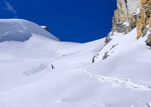
Today will be the longest, toughest, and most exquisite. Since days you were hoping of crossing Audens col and today it will be done. Start by walking on the moraine, you can see Rudgragaira glacier on the right. There is a couple of snow-laden ridges following. Based on the snow level you might be instructed to wear crampons. After crossing the last ridge you will climb up a little to enter the gully.

  • Altitude: 3,900 m / 12,800 ft (Zero Point).
  • Altitude loss: 1,100 m / 3,600 ft.
  • Trek: 11 km, 9-10 hours.
  • 8 km trek is on glacier.
  • The first half of the trail is mixed of loose grave, scree, and black ice.
  • The rest of the trail is of moraine.
  • Camp by the Bhilangna River.
  • Bhilangna river ends at Tehri dam.
  • Packed lunch for the day.
  • Stay in a tent.

Another longest and toughest day. Today we will continue on the rest of the Khatling glacier to arrive at Zero Point camp. The initial 50 m is a steep descend. Watch your steps. The trail will be covered with snow. Climb down the glacier for another 2 km to reach the moraines.

 The trail is filled with loose rocks and scree. The route is also exposed and you can see black ice, icefall, and big ice formations. You will also have to find way through crevasses. From the end of Khatling glacier from the snout, Bhilangnariver originates. Cross the last section of the rockfall and boulder section to reach the campsite.

  • Mandatory Rest day.
  • Rejuvenate yourself.
  • This day also can be used as a buffer day.

This is a purposefully added day for resting. After all the strainful and amazing trek experiences, take rest for this day. This day can be also used as a buffer day in case of unfavourable situations.

  • Altitude: 3,500 m / 11,500 ft (Chowki).
  • Altitude Loss: 400 m / 1,300 ft.
  • Trek: 8 km | 5-6 hours.
  • Comparatively easy day.
  • Will see greenery again.
  • Most of the trek is on Meadow.
  • Fallow Bhilangna river for the first 3km.
  • The campsite is on grassland.
  • One of the best campsites of the trek.
  • Packed/hot lunch, depending on the pace of the group.
  • Stay in a tent.
  • Altitude: 3,750m/12,300ft (Masar Tal).
  • Altitude gain: 250m/800ft.
  • Trek: 8km | 5-6 hours.
  • Easy day.
  • Initially steep ascent then gradual walk.
  • Trail is well defined.
  • Can see the beautiful views of Thalay Sagar peak.
  • Camping near by the Masar Tal (lake).
  • Stay in tent.

Today you will gain a little height to reach the crystal, Masar Tal. The day will be rejuvenated by clear views of Thalaysagar peak. The trail begins with a small ascend showing sights of Thalaysagar. You cross another few ridges. You will also cross a stream until you reach the beautiful Masar Tal. The lake reflects the scenery around it thousand times. You will be lucky to camp beside this lake.

  • Altitude: 5,000m/16,400ft (Mayali Pass)
  • Altitude: 4,200m/13,800ft (Vasuki Tal)
  • Altitude gain: 1,250m/4,100ft.
  • Trek: 12km | 7-9 hours.
  • Masar Tal to Mayali Pass 6km, 5-6 hours.
  • Mayali Pass to Vasuki Tal 6km, 2-4 hours.
  • Steep ascent till Mayali Pass.
  • Steep and technical descent after Mayali Pass.
  • Trail is of boulders and snow.
  • No water source on the way
  • Camping near by the Vasuki tal (Lake).
  • Packed lunch on the way.
  • Stay in tent.

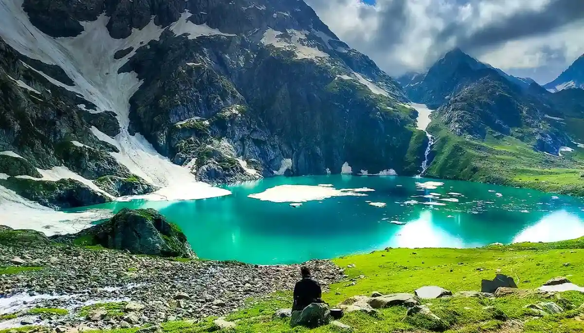
Be excited because today you will visit another and the last pass of the trek, Mayali pass. The trail starts with a climb up over boulders to the Masar top. A climb up for another 45 minutes is needed to reach the base of the pass. This point is outstanding in terms of beauty. There is a lake which is at times semi-frozen with ice bergs floating on its surface.

  • Altitude: 3,500m/11,600ft (Kedarnath).
  • Altitude loss: 700m/2,200ft.
  • Trek: 7km | 3-5 hours.
  • All descent till Kedarnath Temple.
  • Easy and marked trail.
  • Kedarnath temple is dedicated to Lord Shiva.
  • Visit Kedarnath temple in the evening.
  • Hot lunch at guest house.
  • Stay in guest house.

Finally the day has arrived that will end at the mighty Kedarnath. It is one of the Char Dhaams and one of the 12 Jyotirlingas. It has a lot of prime importance in Indian religion. First, start with a ascend to Vasuki Tal top. The trail is boulder filled ridge walk.

  • Altitude: 1,950m/6400ft (Gaurikund).
  • Altitude loss: 1,550m/5,200ft.
  • Trek: 14km | 6-7 hours.
  • All descent till Gaurikund.
  • Easy and marked trail.
  • Many shops and water point on the way.
  • Can go by helicopter (not included in cost).
  • Hot lunch at guest house.
  • Stay in guest house.

This is the final stroll of the thrilling trek. It is a complete long climb down of 14kms. The trail is an easy and well-marked. Try to engulf the most from the last day in the mountains.

  • Driving Distance: 250km |10hrs
  • After morning tea travel towards to Rishikesh
  • Breakfast and Lunch are not included in the trek cost.
  • Reach Rishikesh by 6:00 - 7:00 pm
  • For the safer side book on word journey after 8:30 pm
It’s the last day of the trek and time to go back to the lovely home.  After boarding the pickup vehicle you will arrive in Rishikesh completing a long journey. Note:
  • Keep a buffer day in your travel plan
  • If buffer day is not used in the travel then it can be used to Explore Rishikesh
  • Read the article Things to do in Rishikesh
  • Distance, Altitude, and Trekking hours are approximate and rounded off
  • Keep the original and copy of ID proof handy
  • Come one day early if planning to come by plan

Customer Review

No rating found

GIVE A RATING

Book the Tour